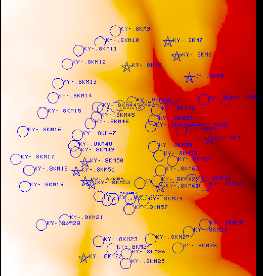
628668.1506 7453299.2505 1 1 1 10 KY-.8km1 lies very close to the large quebrada running NW-SE; an 'island on the mask but??
628607.9092 7453346.2053 1 1 1 10 KY-.8km2 lies very close to the large quebrada running NW-SE; an 'island on the mask but??
628592.7847 7453530.229 1 1 1 10 KY-.8km5 through 8 straddle the quebrada on the NE side.
628545.9375 7453610.5291 1 1 1 10 KY-.8km6
628512.605 7453663.2197 1 1 1 10 KY-.8km7
628358.958 7453569.229 1 1 1 10 KY-.8km8
628197.8325 7452856.9509 1 1 1 10 KY-.8km22 lies in a quebrada, though in a wide place in it.
628202.4019 7453213.644 1 1 1 10 KY-.8km50 thru 53 lie at what looks like an intersection of quebradas.
628170.1519 7453179.8975 1 1 1 10 KY-.8km51
628204.1775 7453142.4819 1 1 1 10 KY-.8km52
628227.7334 7453132.4529 1 1 1 10 KY-.8km53
628407.2061 7453137.3835 1 1 1 1 KY-.8km60 this and 61 appear to lie in a quebrada.
628483.937 7453120.0112 1 1 1 10 KY-.8km61
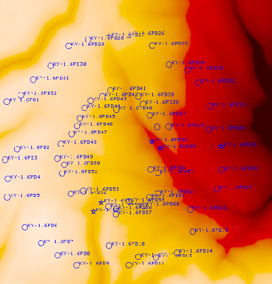
629093.5146 7453312.197 1 1 1 10 KY-1.6Pd19 One of a N-S line of antennas which appear to lie on the W slope of a quebrada
628305.1816 7454083.5913 1 1 1 10 KY-1.6Pd27 appears to lie at the head of a quebrada
628668.1506 7453299.2505 1 1 1 10 KY-1.6Pd33 this pad and 34 look like they are in the quebrada cutting across the siteNW-SE.
628607.9092 7453346.2053 1 1 1 10 KY-1.6Pd34 see above.
628197.8325 7452856.9509 1 1 1 10 KY-1.6Pd54 these two look like they are at the head of a quebrada.
628253.085 7452919.48 1 1 1 10 KY-1.6Pd55 see above.
| SAM56 | SAM56 | Pad | SAM56 | SAM56 | Pad |
| 627590.0959 | 7453626.8711 | KY-1.6Pd1 | 628668.1506 | 7453299.2505 | KY-.8km1 |
| 627662.0669 | 7453293.8772 | KY-1.6Pd2 | 628607.9092 | 7453346.2053 | KY-.8km2 |
| 627578.0654 | 7453219.8843 | KY-1.6Pd3 | 628725.7124 | 7453451.2634 | KY-.8km3 |
| 627596.2673 | 7453085.7136 | KY-1.6Pd4 | 628644.9863 | 7453448.8845 | KY-.8km4 |
| 627592.312 | 7452956.439 | KY-1.6Pd5 | 628592.7847 | 7453530.229 | KY-.8km5 |
| 627717.3716 | 7452746.7312 | KY-1.6Pd6 | 628545.9375 | 7453610.5291 | KY-.8km6 |
| 627831.4519 | 7452634.8401 | KY-1.6Pd7 | 628512.605 | 7453663.2197 | KY-.8km7 |
| 627946.0022 | 7452548.6201 | KY-1.6Pd8 | 628358.958 | 7453569.229 | KY-.8km8 |
| 628079.3655 | 7452479.9021 | KY-1.6Pd9 | 628316.6689 | 7453705.1946 | KY-.8km9 |
| 628307.8022 | 7452617.1865 | KY-1.6Pd10 | 628259.6143 | 7453663.5593 | KY-.8km10 |
| 628446.2468 | 7452480.7324 | KY-1.6Pd11 | 628178.4312 | 7453632.9856 | KY-.8km11 |
| 628511.9946 | 7452538.4219 | KY-1.6Pd12 | 628136.1262 | 7453582.1128 | KY-.8km12 |
| 628636.7883 | 7452534.6577 | KY-1.6Pd13 | 628101.5159 | 7453508.4514 | KY-.8km13 |
| 628784.9734 | 7452566.7698 | KY-1.6Pd14 | 628083.8303 | 7453455.8862 | KY-.8km14 |
| 628894.8354 | 7452714.3762 | KY-1.6Pd15 | 628044.4724 | 7453399.7917 | KY-.8km15 |
| 628878.8691 | 7452869.8875 | KY-1.6Pd16 | 627970.0051 | 7453330.4583 | KY-.8km16 |
| 629063.604 | 7453014.0874 | KY-1.6Pd17 | 627944.3752 | 7453227.1843 | KY-.8km17 |
| 629098.9512 | 7453147.4304 | KY-1.6Pd18 | 627993.3364 | 7453184.7473 | KY-.8km18 |
| 629093.5146 | 7453312.197 | KY-1.6Pd19 | 627978.2102 | 7453124.7642 | KY-.8km19 |
| 629008.0513 | 7453429.1423 | KY-1.6Pd20 | 628039.4197 | 7452980.6743 | KY-.8km20 |
| 629017.147 | 7453593.4158 | KY-1.6Pd21 | 628126.5879 | 7453001.0461 | KY-.8km21 |
| 628936.2764 | 7453759.7625 | KY-1.6Pd22 | 628197.8325 | 7452856.9509 | KY-.8km22 |
| 628857.6089 | 7453850.9746 | KY-1.6Pd23 | 628253.085 | 7452919.48 | KY-.8km23 |
| 628728.5535 | 7453887.5742 | KY-1.6Pd24 | 628302.9202 | 7452891.0735 | KY-.8km24 |
| 628611.165 | 7454019.7305 | KY-1.6Pd25 | 628355.2615 | 7452837.4504 | KY-.8km25 |
| 628446.4436 | 7454091.7109 | KY-1.6Pd26 | 628357.2864 | 7452873.3801 | KY-.8km26 |
| 628305.1816 | 7454083.5913 | KY-1.6Pd27 | 628447.79 | 7452927.9119 | KY-.8km27 |
| 628159.5273 | 7454060.3833 | KY-1.6Pd28 | 628549.2883 | 7452895.1909 | KY-.8km28 |
| 628024.0381 | 7454017.7534 | KY-1.6Pd29 | 628589.2886 | 7452955.1545 | KY-.8km29 |
| 627897.3875 | 7453876.2065 | KY-1.6Pd30 | 628650.0017 | 7452982.3315 | KY-.8km30 |
| 627775.4678 | 7453780.2334 | KY-1.6Pd31 | 628649.8911 | 7453128.0559 | KY-.8km31 |
| 627689.3669 | 7453672.0139 | KY-1.6Pd32 | 628601.0779 | 7453150.7161 | KY-.8km32 |
| 628668.1506 | 7453299.2505 | KY-1.6Pd33 | 628478.647 | 7453239.9023 | KY-.8km33 |
| 628607.9092 | 7453346.2053 | KY-1.6Pd34 | 628459.2783 | 7453272.4746 | KY-.8km34 |
| 628725.7124 | 7453451.2634 | KY-1.6Pd35 | 628561.9944 | 7453333.4353 | KY-.8km35 |
| 628644.9863 | 7453448.8845 | KY-1.6Pd36 | 628448.158 | 7453348.3374 | KY-.8km36 |
| 628592.7847 | 7453530.229 | KY-1.6Pd37 | 628459.9851 | 7453371.9128 | KY-.8km37 |
| 628545.9375 | 7453610.5291 | KY-1.6Pd38 | 628469.3354 | 7453409.3433 | KY-.8km38 |
| 628512.605 | 7453663.2197 | KY-1.6Pd39 | 628406.9893 | 7453429.7603 | KY-.8km39 |
| 628358.958 | 7453569.229 | KY-1.6Pd40 | 628376.8423 | 7453439.9312 | KY-.8km40 |
| 628316.6689 | 7453705.1946 | KY-1.6Pd41 | 628333.4001 | 7453427.4082 | KY-.8km41 |
| 628259.6143 | 7453663.5593 | KY-1.6Pd42 | 628320.105 | 7453420.4087 | KY-.8km42 |
| 628178.4312 | 7453632.9856 | KY-1.6Pd43 | 628267.0447 | 7453413.4863 | KY-.8km43 |
| 628136.1262 | 7453582.1128 | KY-1.6Pd44 | 628249.0615 | 7453420.4543 | KY-.8km44 |
| 628101.5159 | 7453508.4514 | KY-1.6Pd45 | 628244.8821 | 7453384.2551 | KY-.8km45 |
| 628083.8303 | 7453455.8862 | KY-1.6Pd46 | 628222.7739 | 7453359.9705 | KY-.8km46 |
| 628044.4724 | 7453399.7917 | KY-1.6Pd47 | 628174.1699 | 7453316.6021 | KY-.8km47 |
| 627970.0051 | 7453330.4583 | KY-1.6Pd48 | 628160.9165 | 7453276.3738 | KY-.8km48 |
| 627944.3752 | 7453227.1843 | KY-1.6Pd49 | 628167.2488 | 7453253.6484 | KY-.8km49 |
| 627993.3364 | 7453184.7473 | KY-1.6Pd50 | 628202.4019 | 7453213.644 | KY-.8km50 |
| 627978.2102 | 7453124.7642 | KY-1.6Pd51 | 628170.1519 | 7453179.8975 | KY-.8km51 |
| 628039.4197 | 7452980.6743 | KY-1.6Pd52 | 628204.1775 | 7453142.4819 | KY-.8km52 |
| 628126.5879 | 7453001.0461 | KY-1.6Pd53 | 628227.7334 | 7453132.4529 | KY-.8km53 |
| 628197.8325 | 7452856.9509 | KY-1.6Pd54 | 628256.6072 | 7453087.2134 | KY-.8km54 |
| 628253.085 | 7452919.48 | KY-1.6Pd55 | 628286.0903 | 7453072.6963 | KY-.8km55 |
| 628302.9202 | 7452891.0735 | KY-1.6Pd56 | 628308.9221 | 7453078.5603 | KY-.8km56 |
| 628355.2615 | 7452837.4504 | KY-1.6Pd57 | 628367.322 | 7453039.8657 | KY-.8km57 |
| 628357.2864 | 7452873.3801 | KY-1.6Pd58 | 628371.5608 | 7453078.144 | KY-.8km58 |
| 628447.79 | 7452927.9119 | KY-1.6Pd59 | 628421.5312 | 7453072.7107 | KY-.8km59 |
| 628549.2883 | 7452895.1909 | KY-1.6Pd60 | 628407.2061 | 7453137.3835 | KY-.8km60 |
| 628589.2886 | 7452955.1545 | KY-1.6Pd61 | 628483.937 | 7453120.0112 | KY-.8km61 |
| 628650.0017 | 7452982.3315 | KY-1.6Pd62 | 628470.4363 | 7453144.2427 | KY-.8km62 |
| 628649.8911 | 7453128.0559 | KY-1.6Pd63 | 628484.9695 | 7453183.1448 | KY-.8km63 |
| 628601.0779 | 7453150.7161 | KY-1.6Pd64 | 628529.3088 | 7453219.8726 | KY-.8km64 |